Borobudur Temple

enjoy your travel journey by visit the culture heritage site of human civilization in Borobudur Temple.

Skydive at Great Barrier Reef

feel your adrenaline increase when skydiving at whitesunday

Rio de Janeiro

Explore the amazing City

Enjoy the beauty of Bondi Beach

don't miss to enjoy the romantic atmosphere of bondi beach at the night.

Let's become traveller

Prepare Your self to uncover the beauty of the world.

Showing posts with label America. Show all posts

Monday, June 22, 2015

Easter Island – “The Center of the World”

Tepito Ote Henua (“The Center of the World”), as the people who lived there once called it, is the most remote inhabited island on the planet. No other landmass is as isolated, which gives it an aura of mystery.
Easter Island is a National Park and UNESCO World Heritage Site, and it offers something for everyone: pink sand beaches like Ovahe, the heavenly charms of Anakena, volcanoes and grasslands to explore on foot or on horseback, marine life you can discover on diving trips, silent caverns and the Moai statues that bore witness to the rise and fall of a complex and stratified society.

It’s estimated that the first inhabitants of Easter Island came from the Marquesas Islands in the 6th century and had no contact with the outside world for more than a thousand years. On Easter Sunday, 1722, this place became known to the Western world thanks to Dutch sailor Jakob Roggeveen, who described the Rapa Nui people as “a subtle culture of beautiful women and kind men.”

The island was home to a complex culture that fell into disarray due to food shortages and the tribal warfare that ensued. But its spirit lives on in its people, language, clothing, music, dance, crafts and food. Every February, the people celebrate a return to their roots with Tapati, two weeks of festivities based on ancestral traditions such as body painting, awe-inspiring competitions, song, dance and the selection of their queen.
The island has plenty to offer the rest of the year as well. Its climate is always warm, its tourism and service infrastructure is continually improving, and the tranquility and beauty of its landscapes coupled with the charm of its people will make you want to return.

There are seven weekly flights from Santiago to Matavari Airport in Hanga Roa (5 h 25 min). There are currently no other flights to the island from anywhere else in the world.

Valle del Elqui – An Oasis for the Senses


The Elqui River runs some 140 km to the beaches of La Serena, passing through hills laden with vineyards and towns that have made blending agriculture and tourism a local tradition. This is Valle del Elqui (Elqui Valley), one of the country’s most popular tourist destinations and the perfect destination for those looking to connect with nature and enjoy a different kind of vacation experience.
Take a paved road east from La Serena (62 km) to the tranquil city of Vicuña, which is best known as the birthplace of Nobel Prize-winning poet Gabriela Mistral. From here, you can venture further into the valley and visit Monte Grande, the town where Mistral spent her childhood. It is still home to her school, her home and her gravesite.
There are many ways to experience this destination, and a visit to the pisco plants is a good place to start. Tours offer a great opportunity to learn about the production process, taste this grape distillate and shop.

Towns like Algarobillo, El Tambo, Peralillo, El Molle and San Isidro offer a relaxed atmosphere, plenty of vineyards and orchards, adobe architecture and beautiful churches.If you’re a fan of adventure sports, try the local trekking routes, horseback riding excursions and paths for bike and Jeep tours.

Vicuña and Pisco Elqui are surrounded by vineyards and have excellent restaurants and “picadas” (small local restuarants) which serve everything from roasted goat to organic cuisine. Ask the locals for recommendations, especially when it comes to marmalades, empanadas, pan amasado (kneaded bread) and manjar.

Valle del Elqui has attracted a number of people who are looking to live far from the hectic pace of city life. Given that this place is a source of healing energies, it’s easy to find accommodations that offer alternative therapies, including reiki, meditation and massages. The beautiful landscapes of the nearby Cochiguaz Valley are home to a center that focuses on mysticism and alternative therapies.

To complete this journey of the senses, visit the Mamalluca Astronomy Center. The pure Valle del Elqui air allows for some spectacular stargazing opportunities.


Source : http://chile.travel/en/

Sunday, June 21, 2015

The Perito Moreno Glacier

The Perito Moreno Glacier was named after the Argentine naturalist and explorer, Perito Francisco Pascacio Moreno (1852-1919), who, among other things, donated the land for the first Argentine National Park and acted as an expert (perito, in Spanish) regarding the border with Chile because of his extensive knowledge of the Patagonian mountain range. Nevertheless, he never saw the glacier that was named after him.

The first man to ever set foot in this glacier was Juan Tomas Rogers, the English captain of the Chilean Army, in 1879. It was not until the beginning of the 20th century that the Glacier became known through the scientific work and pictures taken by Hauthal. Later on, the unstoppable Federico Reichert, the father of Argentine Andean mountaineering, walked through the glacier up to its source in the Southern Patagonia Ice Cap in 1912.The glacier became more and more popular year after year and today it is the best-known glacier in the world.


We will begin by defining a glacier as an immense mass of ice which has two very different zones: the accumulation zone and the percolation zone. In the accumulation zone, it is constantly snowing. In the percolation zone, the glacier looses ice mass due to evaporation and melting (mainly in summertime). These huge masses of ice move down due to the slope of the valleys in which they are situated and end abruptly in lakes or cliffs, or softly forming terminal moraines (accumulations of stones and dirt pushed by the glacier).
It is worth mentioning that there are glaciers in many areas of the world: the Andes, the Alps, the Himalayas (Nepal), Antarctica, New Zealand, Karakorum (Pakistan), the North Pole, and even in Africa!!!, in Mount Kilimanjaro and Mount Kenya. But none of them has the unique features of the Moreno Glacier.

There are 3 main features that make this glacier different from the others: its access, its condition and the breaking phenomenon.
1) Access: Few glaciers in the world can be accessed in such a simple and safe way as this one. The Moreno Glacier is located at 185m above sea level and 80km away from El Calafate (the nearest town). You can walk over the glacier after a short 15-minute walk around Lake Rico. Most glaciers are in very high places or in places with extreme temperatures, so this is one of the reasons why Moreno Glacier is so popular.
2) Condition: Since 1917, the Perito Moreno Glacier is stable, meaning that its surface, width and length have remained the same since then. This shows that the snow increase in the accumulation zone is enough to compensate what is lost in the percolation zone, mainly on account of melting.
3) Breaking: This spectacular and unique phenomenon has taken place since 1940, when the first known breaking took place. 
The breaking process begins when the glacier reaches the Magallanes Peninsula, obstructing the drainage of the Lake Rico into the Lago Argentino. This causes the level of the Lake Rico to rise every day because of the ice melting in the highlands and the lack of drainage. Some months or years later, the pressure produced by all that water (7m in the last breaking of March 2006) causes the glacier to break. The breaking itself can take between one day and a whole week, depending on the amount of water accumulated in Lake Rico and the ice mass preventing the water from passing through.
The breaking cycles are very irregular and vary from 2 to 16 years. We were very lucky with the breakings of 2004 and 2006, but the previous breaking had taken place in 1988!


Source : www.hieloyaventura.com


Rio de Janeiro

The citizens of the fourteen-million-strong city of Rio de Janeiro call it the Cidade Marvilhosa – and there can’t be much argument about that. Although riven by inequality, Rio has great style. Its international renown is bolstered by a series of symbols that rank as some of the greatest landmarks in the world: the Corcovado mountain supporting the great statue of Christ the Redeemer; the rounded incline of the Sugar Loaf mountain, standing at the entrance to the bay; and the famous sweeps of Copacabana and Ipanema beaches, probably the most notable lengths of sand on the planet. It’s a setting enhanced annually by the frenetic sensuality of Carnaval, an explosive celebration that – for many people – sums up Rio and its citizens, the cariocas. 

The major downside in a city given over to conspicuous consumption is the rapacious development that has engulfed Rio. As the rural poor, escaping drought and poverty in other regions of Brazil, swell Rio’s population, the city has been squeezed like a toothpaste tube between mountains and sea, pushing its human contents ever further out along the coast. Over the decades, much of the city’s rich architectural heritage has been whittled away, along with the destruction of much of its natural environment.


Sitting on the southern shore of the magnificent Guanabara Bay, Rio has, without a shadow of a doubt, one of the most stunning settings in the world. Extending for 20km along an alluvial strip, between an azure sea and forest-clad mountains, the city’s streets and buildings have been moulded around the foothills of the mountain range that provides its backdrop, while out in the bay there are many rocky islands fringed with white sand. The aerial views over Rio are breathtaking, and even the concrete skyscrapers that dominate the city’s skyline add to the attraction. As the former capital of Brazil and now its second largest city, Rio has a remarkable architectural heritage, some of the country’s best museums and galleries, superb restaurants and a vibrant nightlife – in addition to its legendary beaches. With so much to see and do, Rio can easily occupy a week and you may well find it difficult to drag yourself away.


Rio de Janiero carnaval
The state of Rio de Janeiro, surrounding the city, is a fairly recent phenomenon, established in 1975 as a result of the amalgamation of Guanabara state and Rio city, the former federal capital. Fairly small by Brazilian standards, the state is both beautiful and accessible, with easy trips either northeast along the Costa do Sol or southwest along the Costa Verde, taking in unspoilt beaches, washed by a relatively unpolluted ocean. Inland routes make a welcome change from the sands, especially the trip to Petrópolis, a nineteenth-century mountain retreat for Rio’s rich.

The best time to visit both city and state, at least as far as the climate goes, is between May and August, when the region is cooled by trade winds, the temperature remains at around 22–32°C and the sky tends to be clear. Between December and March (the rainy season), it’s more humid, with the temperature hovering around 40°C; but even then it’s rarely as oppressive as it is in northern Brazil, and there’s a chance of blue sky for at least part of the day.


Source : www.roughguides.com

San Ignacio MinÍ

The most famous of all the reducciones, San Ignacio Miní was originally founded in 1610 in the Guayrá region, in what is now Brazil. After the bandeirantes attacked the mission in 1631, the Jesuits moved thousands of miles southwards through the jungle, stopping several times en route at various temporary settlements before finally re-establishing the reducción at its present site in 1696.

The ruins occupy six blocks at the northeastern end of the village of San Ignacio: from the bus stop head east along Avenida Sarmiento for two blocks and turn left onto Rivadavia. Follow Rivadavia, which skirts around the ruins, for six blocks and then turn right onto Alberdi, where you’ll find the entrance to the site. At the entrance, there’s a small but worthwhile museum with a series of themed rooms depicting various aspects of Guaraní and mission life, plus a detailed maquette of the entire reducción. The site itself is dotted with panels lending context to the ruins, with audio provided in various languages, including English. Free, more detailed tours in rapid-fire Spanish depart regularly from the museum. There are also popular sound and light shows each evening.

On entering the settlement itself, you’ll come first to rows of simple viviendas, or living quarters, a series of six to ten adjoining one-roomed structures, each of which housed a Guaraní family. Like all the mission settlements, these are constructed in a mixture of basaltic rock and sandstone. Passing between the viviendas, you arrive at the spacious Plaza de Armas, whose emerald grass provides a stunning contrast with the rich red hues of the sandstone. At the southern end of the plaza, and dominating the entire site, stands the magnificent facade of San Ignacio’s church, designed, like Santa Ana’s, by the Italian architect Brazanelli. The roof and much of the interior have long since crumbled away, but two large chunks of wall on either side of the entrance remain, rising out of the ruins like two great Baroque wings. 
Though somewhat eroded, many fine details can still be made out: two columns flank either side of the doorway and much of the walls’ surface is covered with decorative bas-relief sculpture executed by Guaraní craftsmen. Most striking are the pair of angels that face each other high up on either side of the entrance, while a more austere touch is added by the prominent insignia of the Jesuit order on the right-hand side of the entrance.

To the left of the main entrance, you can wander around the cloisters and priests’ quarters, where a number of other fine doorways and carvings remain. Particularly striking is the doorway connecting the cloisters with the church baptistry, flanked by ribbed columns with heavily moulded bases and still retaining a triangular pediment over the arched doorway.


Source: www.roughguides.com

Saturday, June 20, 2015

Iguazú falls

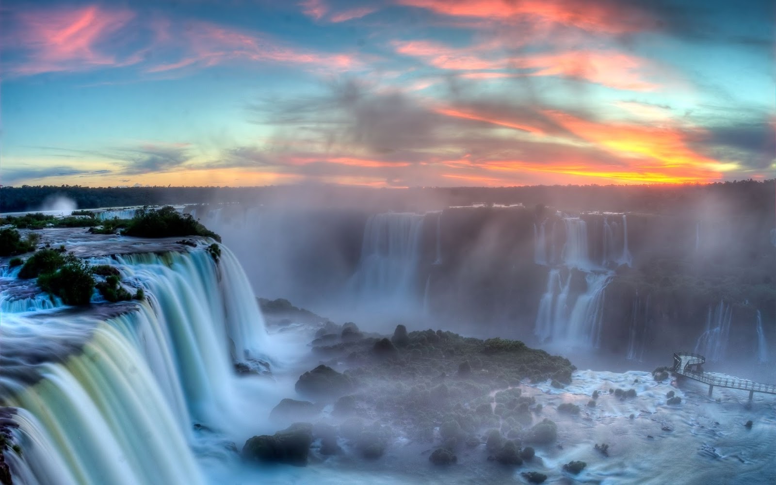
Composed of over 250 separate cascades, and straddling the border between Argentina and Brazil, the Iguazú Falls (or “Cataratas”, as they are known locally) are quite simply the world’s most dramatic waterfalls. Set among the exotic-looking subtropical forests of Parque Nacional Iguazú in Argentina, and Parque Nacional do Iguaçu in Brazil, the Falls tumble for a couple of kilometres over a complex set of cliffs from the Río Iguazú Superior to the Río Iguazú Inferior below. At their heart is the dizzying Garganta del Diablo, a powerhouse display of natural forces in which 1800 cubic metres of water per second hurtle over a 3km semicircle of rock into the boiling river canyon 70m below.


The first Europeans to encounter the Falls, in 1542, were members of a Spanish expedition led by Cabeza de Vaca, who named them the Saltos de Santa María. For nearly five hundred years, however, they remained practically forgotten in this remote corner of Argentina, and it wasn’t until the early twentieth century that tourism began to arrive, encouraged by the then governor of Misiones, Juan J. Lanusse. The first hotel was constructed in 1922, right by the Falls, and by the mid-twentieth century Iguazú was firmly on the tourist map. Today, the Falls are one of Latin America’s major tourist attractions, with around two million visitors each year.

The Argentine side

The vast majority of the Iguazú Falls lie on the Argentine side of the border, within the Parque Nacional Iguazú. This side offers the most extensive experience of the cataratas, thanks to its well-planned system of trails and catwalks taking you both below and above the waters – most notably to the Garganta del Diablo. The surrounding forest also offers excellent opportunities to view the region’s wildlife. The main settlement on this side, Puerto Iguazú, lies approximately 18km northwest of the park entrance with a slightly sleepy, villagey feel, though its popularity with backpackers has livened it up a bit in recent years.
Garganta del Diablo
To visit the Garganta del Diablo (“Devil’s Throat”), you must take the Tren de la selva (“Jungle Train”), which leaves regularly from Estación Cataratas, for the Estación Garganta del Diablo, 3km southeast (fare included in entrance fee). From here a catwalk with a small viewing platform takes you to within just a few metres of the staggering, sheer drop of water formed by the union of several immensely powerful waterfalls around a kind of horseshoe. As the water crashes over the edge, it plunges into a dazzling opaque whiteness in which it is impossible to distinguish mist from water. The vencejos often swirl around the waterfall in all directions, forming giant swarms that sometimes swoop up towards you and perform miraculous acrobatic twists and turns – quite a sight. If you’re bringing your camera, make sure you’ve an airtight bag to stash it in, as the platform is invariably showered with a fine spray.

The Brazilian side

To complete your trip to Iguazú, you should also try and visit the Brazilian side. You’ll only need a few hours but it’s worth crossing in order to take photos of the Falls – particularly in the morning – as it provides you with a superb panorama of the points you will have visited close up in Argentina, as well as its own close encounter with the Garganta del Diablo. Though it offers a more passive experience, the view is more panoramic and the photo opportunities are amazing. You can cross for the day but, if you want to stay in Brazil, the city of Foz do Iguaçu lies a good 20km northwest of the access to the park. Much larger than Puerto Iguazú and with a modern, urban feel, Foz is neither the most beautiful nor most exotic of Brazilian cities, but if you’ve been travelling in Argentina for a while it’ll give you the chance to hear another language, try some different food and sample some lively nightlife. Foz definitely feels less safe than its Argentine counterpart – a fact much exaggerated by Argentines, but nonetheless you should be on your guard in the city.


Source: www.roughguides.com