Borobudur Temple

enjoy your travel journey by visit the culture heritage site of human civilization in Borobudur Temple.

Skydive at Great Barrier Reef

feel your adrenaline increase when skydiving at whitesunday

Rio de Janeiro

Explore the amazing City

Enjoy the beauty of Bondi Beach

don't miss to enjoy the romantic atmosphere of bondi beach at the night.

Let's become traveller

Prepare Your self to uncover the beauty of the world.

Wednesday, July 1, 2015

Kuta Beach


About...


Once a sleepy village with a quiet, beautiful sweep of beach, Kuta today has become a popular beach destination in its own right, alive with tourists from all over the world, swimming, surfing or sunbathing by the beach. Others, casually dressed in shorts, T-shirts and flip-flops stroll along its main road, shopping around or enjoying meals at its many open air restaurants. When in Kuta you know that you are in a holiday town, and people here are in a holiday mood. 
Back in the 1960’s the only hotel was the Kuta Beach Hotel, but soon without much planning, Kuta developed rapidly into a haunt for surfers and backpackers, while the high end market preferred to stay at the more sedate Sanur village on the opposite side of the peninsula.


With time, Kuta’s popularity grew, and shops, restaurants, discos hotels, - from the simple to the exclusive - sprang up along the main road from Kuta to Legian, catering to the ever increasing holiday crowd, that not only included international tourists but also domestic visitors from Jakarta and other big cities. 
On the beach, people enjoy parasailing, banana boat trips or swimming Women offer traditional Indonesian massage on the beach, others are seen plaiting hair. 
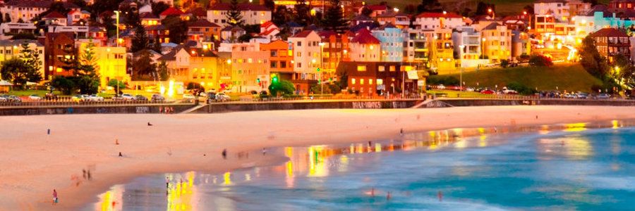
Before sunset, crowds rush to the beach waiting to watch Kuta’s legendary sunsets. Then as darkness falls, Kuta’s nightlife starts to throb with loud music from bars and restaurants, while shops stay open till late at night. Kuta’s main attraction is that everyone can enjoy the town without any prescribed dress code. 
Many famous international bands and celebrities have voluntarily played and sung here enlivening the fun, dance and music scene of Kuta. 

One poignant reminder, however, of the tragedy that befell Kuta is a monument located next to the present Paddy’s café. The monument is erected in memory of those killed during the fatal October 2002 bomb terrorist blasts. The blasts killed more than 300 people, mostly Australian tourists and Indonesian workers. 


What to do?

Moving around Kuta its very fun and simple. You can go around on foot or you can rent a bike or motorcycleMany visitors come here to shop.
Kuta is a manufacturing center for summer wear, jewelry and decorative handicrafts that are exported all over the world. So shop here to your heart’s content for summer chic to beach wear, including wonderfully creative accessories from shoes, handbags to bracelets, necklaces and earrings. There are department stores to boutiques, to roadside stalls. Popular night spots on Kuta include the Hard Rock Café, De Ja Vu, the Bali  Globe, Paddy’s Café and many more. 


How to reached?

The first of course you must go to bali island. if you from jakarta, you can get there by flight route Jakarta-Bali. after you landed in bali, kuta beach can be reache by taxi. There are plenty of taxis that can take you to Kuta beach. You can rent these by the meter or by the hour. Taking your own car is not recommended as parking here is very tight.

Where to stay?

Kuta is the ultimate beach resort catering to any taste and budget. You may stay at five star hotels, or at clean “losmen” or home stays. In the hotel complex you will have privacy at the hotel’s own beach front or swimming pool, but when you stroll out you will be met with the hustle and bustle of the town centre. There are various foreign and local restaurants that offering international and local foods. These restaurants are available along Kuta.

Saturday, June 27, 2015

Fish River Canyon


The Fish River Canyon is located in southern Namibia, West Africa. As the second largest canyon in the world, it's a very popular destination among tourists. Although dry with only a small series of pools for most of the year, late summer flooding breathes new life into the 404 mile Fish River. Spectacular panoramic views await visitors of the Fish River Canyon, particularly at Hell's Bend, a scenic overlook named after a horseshoe shaped bend in the river.


With a length of 650 kilometres the Fish River is the longest river in Namibia. Its source lies in the eastern Naukluft Mountains. South-west of Ai-Ais it flows into the Oranje. The Fish River canyon, situated along the lower reaches of the Fish River, is one of the most impressive natural beauties in the southern part of Namibia. With a depth of up to 550 metres, the Fish River Canyon is the second largest canyon in the world. The enormous gorge meanders along a distance of approx. 160 kilometres through the fissured Koubis massif all the way down to Ai-Ais. The canyon starts near Seeheim. It is 161 kilometres long and ends at Ai-Ais.


The Fish River Canyon probably formed about 500 million years ago during the pluvial times - a rainy climatic epoch - many millions of years ago. However, the gorge was not only created by water erosion, but also through the collapse of the valley bottom due to movements in the earth's crust. Because the Fish River is being dammed in Hardap near Mariental, it only contains a small amount of running water. In winter, during the dry season, the river bed is often completely dry or reduced to just some puddles here and there. However, after rainfalls in summer the river can become a raging torrent.
Exteriors of the resort


The canyon is part of a national nature conservation park. The gate is situated at the restcamp Hobas. From there, you have to drive another 10 kilometres to the actual canyon which offers a stunning view of the famous "Hell's Bend".
relax while enjoying the atmosphere of the wild
The Fish River Canyon has become a popular hiking destination. However, hikes require good physical health and can only be undertaken during the cooler winter months (between May and September). A permit from Namibia Wildlife Resorts in Windhoek must be obtained. The hike is 86 km in length and takes about 5 days. Much easier hikes, no less beautiful, are offered in the bordering private "Canyon Nature Park". The adjacent "Gondwana Canyon Park", also private, offers scenic hikes as well. They also have excellent accommodation.
don't miss this atmosphere

Friday, June 26, 2015

The Matterhorn


Situated in the Pennine Alps on the border between Switzerland and Italy is one of the most famous and distinctive of all Alpine peaks. The Matterhorn is a pyramidal-shaped colossus, standing at a skyline-dominating 4478 metres (14,690 feet). Its four steep faces rise above the nearby glaciers and face the four compass points, north, east, south and west. Although not the highest peak in the Alps its fame is due to its almost impossible shape; an unusual landform with a summit that appears to extend over its north face, making it look like a cobra about to strike.
The formation of the Matterhorn (and the rest of the Alps) began some 50 to 60 million years ago when the African and Eurasian tectonic plates collided, and layers of sedimentary rock that had formed in the seas between them were thrust up above sea level. Experts suggest that the Matterhorn began as a rounded hill, but gained its distinct pyramidal shape as a result of natural erosive forces over the last million years.
The first successful ascent of this iconic peak was on July 14, 1865 by a team led by English illustrator, climber and explorer Edward Whymper. He had previously made several unsuccessful attempts on the summit. The climb was marred by tragedy as four team members lost their lives in a fall just below the summit during the descent. The second ascent occurred just three days after Whymper’s triumph, from the Italian side. The mountain’s difficult north face wasn’t climbed until July 31 and August 1, 1931.
The Matterhorn’s north face overlooks the Swiss Zmutt Valley, whilst the south stands guard over the Italian ski resort village of Breuil-Cervinia. The Theodul Pass, a trade route used by Ancient Romans and Celts as early as 100BC connects the two destinations. Unknown to most, the Romans originally named the Matterhorn, ‘Mons Silvius’. In fact, it wasn’t until sometime during the 1500’s that Germans named the mountain, the Matterhorn, derived from “matte” meaning meadow and “horn” meaning peak
climbing route
The climbs are long and demanding and it’s essential that climbers have previous alpine mountaineering experience. The usual route is up the Hörnli ridge, also called the North-East ridge. This is the central ridge that can be seen from the village of Zermatt at the foot of the mountain. The ascent starts at Hörnli Hut, a mountain hut situated at 3,260 metres (10,700 ft.) above sea level. It involves 4,000 feet of climbing and takes around six hours up and five hours down. There are fixed ropes on some parts of the climb. Although this is considered the easiest ascent it has an AD (fairly difficult) rating. Other routes on the mountain include the Zmutt ridge, the north face, and the Italian ridge (South-West or ‘Lion’ ridge) which was the route taken by the party that reached the summit three days after Whymper.
zermatt camp
If you are attempting to climb the Matterhorn the best times are from mid-July to mid-September, depending on the amount of snow on the mountain. However, it’s important to bear in mind that the weather on the mountain is dangerously unpredictable and changes commonly occur throughout the day.
ermatt is the world-renowned resort village at the foot of the Matterhorn, boasting luxury hotels, boutiques, restaurants and health spas. It is situated in the canton of Valais in the west of Switzerland.
milky way from matterhorn
International flights into Switzerland arrive at either Geneva or Zurich airports, with both providing easy access to Zermatt through the Swiss rail network. Train is the most convenient way to get to Zermatt as it is a car-free village. Only electric cars are allowed to operate within its boundaries.

Source : www.beautifulworld.com

The Meteora

The Meteora are a collective of natural sandstone rock pillars, which have served as places of worship throughout modern history. With an average elevation of 313m (1027ft), the Meteora rocks stand proudly at the centre of an extraordinarily beautiful Greek landscape, housing 24 monasteries in total, of which 6 remain active. Inscribed on the UNESCO World Heritage List in 1988, Meteora attracts tourists to the region in their thousands each year.

The name, ‘Meteora’ stems from the Greek adjective, meteoros, which means ‘middle of the sky’. Aptly named, the rock formations of Meteora jut out of the ground like giant fingers made of stone, allowing the various monasteries to sit, suspended in the air. It has taken millions of years for various forces of nature to sculpt out these unique rock pillars. Geologists believe that this process began approximately 60 million years ago during the Palaeogene period.
 interior of monastery
As early as the 11th century, monks occupied the caverns of Meteora. However, monasteries were not built until the 14th century, when the monks sought somewhere to hide in the face of an increasing number of Turkish attacks on Greece. At this time, access to the top was via removable ladders or windlass. Nowadays, getting up is a lot simpler due to steps being carved into the rock during the 1920’s. Of the 24 monasteries, only 6 (five male, one female) are still functioning, with each housing less than 10 individuals.

Meteora is not only a paradise for walkers, but for climbers too. In total, there are 700 different routes, encompassing 120 rock towers of the Meteora, and catering for climbers of all skill levels. If you are travelling with the intention of climbing, the best times to visit are between mid-March to mid-June or between mid-August to mid-November.

Given the cultural significance and popularity of Meteora, there are visitors all year round. Between December and March, the weather is cold and wet, whilst the months in-between July and October attract the largest crowds and peak season rates. Therefore, the best time to visit Meteora is in May or June in order to benefit from smaller crowds, pleasant weather and off-season rates.

The Meteora rocks are situated right in the heartland of central Greece (Thessaly), near the town of Kalampaka. To get to Kalampaka from Athens (218mi / 352km), you have the option of traveling by bus, car, or train. If you have a car, driving is probably the best way to get to Meteora, and should take approximately 4 hours, notwithstanding any traffic. If driving is not an option, you can take a direct, high-speed train from Athens to Kalampaka, which will take around 5 hours. Finally, and as a last resort, there are buses that can take you from Athens to Trikala, and then from Trikala to Kalampaka. These depart from Terminal B on Liosson Street and take 7-8 hours to arrive.


Source : www.beautifulworld.com

Tuesday, June 23, 2015

St. Moritz


Monday, June 22, 2015

Easter Island – “The Center of the World”

Tepito Ote Henua (“The Center of the World”), as the people who lived there once called it, is the most remote inhabited island on the planet. No other landmass is as isolated, which gives it an aura of mystery.
Easter Island is a National Park and UNESCO World Heritage Site, and it offers something for everyone: pink sand beaches like Ovahe, the heavenly charms of Anakena, volcanoes and grasslands to explore on foot or on horseback, marine life you can discover on diving trips, silent caverns and the Moai statues that bore witness to the rise and fall of a complex and stratified society.

It’s estimated that the first inhabitants of Easter Island came from the Marquesas Islands in the 6th century and had no contact with the outside world for more than a thousand years. On Easter Sunday, 1722, this place became known to the Western world thanks to Dutch sailor Jakob Roggeveen, who described the Rapa Nui people as “a subtle culture of beautiful women and kind men.”

The island was home to a complex culture that fell into disarray due to food shortages and the tribal warfare that ensued. But its spirit lives on in its people, language, clothing, music, dance, crafts and food. Every February, the people celebrate a return to their roots with Tapati, two weeks of festivities based on ancestral traditions such as body painting, awe-inspiring competitions, song, dance and the selection of their queen.
The island has plenty to offer the rest of the year as well. Its climate is always warm, its tourism and service infrastructure is continually improving, and the tranquility and beauty of its landscapes coupled with the charm of its people will make you want to return.

There are seven weekly flights from Santiago to Matavari Airport in Hanga Roa (5 h 25 min). There are currently no other flights to the island from anywhere else in the world.

Valle del Elqui – An Oasis for the Senses


The Elqui River runs some 140 km to the beaches of La Serena, passing through hills laden with vineyards and towns that have made blending agriculture and tourism a local tradition. This is Valle del Elqui (Elqui Valley), one of the country’s most popular tourist destinations and the perfect destination for those looking to connect with nature and enjoy a different kind of vacation experience.
Take a paved road east from La Serena (62 km) to the tranquil city of Vicuña, which is best known as the birthplace of Nobel Prize-winning poet Gabriela Mistral. From here, you can venture further into the valley and visit Monte Grande, the town where Mistral spent her childhood. It is still home to her school, her home and her gravesite.
There are many ways to experience this destination, and a visit to the pisco plants is a good place to start. Tours offer a great opportunity to learn about the production process, taste this grape distillate and shop.

Towns like Algarobillo, El Tambo, Peralillo, El Molle and San Isidro offer a relaxed atmosphere, plenty of vineyards and orchards, adobe architecture and beautiful churches.If you’re a fan of adventure sports, try the local trekking routes, horseback riding excursions and paths for bike and Jeep tours.

Vicuña and Pisco Elqui are surrounded by vineyards and have excellent restaurants and “picadas” (small local restuarants) which serve everything from roasted goat to organic cuisine. Ask the locals for recommendations, especially when it comes to marmalades, empanadas, pan amasado (kneaded bread) and manjar.

Valle del Elqui has attracted a number of people who are looking to live far from the hectic pace of city life. Given that this place is a source of healing energies, it’s easy to find accommodations that offer alternative therapies, including reiki, meditation and massages. The beautiful landscapes of the nearby Cochiguaz Valley are home to a center that focuses on mysticism and alternative therapies.

To complete this journey of the senses, visit the Mamalluca Astronomy Center. The pure Valle del Elqui air allows for some spectacular stargazing opportunities.


Source : http://chile.travel/en/

Sunday, June 21, 2015

Arc de triomphe


If anything rivals the Eiffel Tower as the symbol of Paris, it’s this magnificent 1836 monument to Napoleon’s 1805 victory at Austerlitz, which he commissioned the following year. The intricately sculpted triumphal arch stands sentinel in the centre of the Étoile (‘star’) roundabout. From the viewing platform on top of the arch (50m up via 284 steps and well worth the climb) you can see the dozen avenues.
Av de la Grande Armée heads northwest to the skyscraper district of La Défense, where the Grande Arche marks the western end of the Axe Historique.
The most famous of the four high-relief panels at the base is to the right, facing the arch from the av des Champs-Élysées side. It’s entitled Départ des Volontaires de 1792 (Departure of the Volunteers of 1792) and is also known as La Marseillaise (France’s national anthem). Higher up, a frieze running around the whole monument depicts hundreds of figures, each one 2m high.
Beneath the arch at ground level lies the Tomb of the Unknown Soldier. Honouring the 1.3 million French soldiers who lost their lives in WWI, the Unknown Soldier was laid to rest in 1921, beneath an eternal flame which is rekindled daily at 6.30pm.
Don’t cross the traffic-choked roundabout above ground if you value your life! Stairs lead from the northern side of the Champs-Élysées beneath the Étoile to pedestrian tunnels (not linked to metro tunnels) that bring you out safely beneath the arch. Tickets to the viewing platform are sold in the tunnel.

Source: www.lonelyplanet.com

The Perito Moreno Glacier

The Perito Moreno Glacier was named after the Argentine naturalist and explorer, Perito Francisco Pascacio Moreno (1852-1919), who, among other things, donated the land for the first Argentine National Park and acted as an expert (perito, in Spanish) regarding the border with Chile because of his extensive knowledge of the Patagonian mountain range. Nevertheless, he never saw the glacier that was named after him.

The first man to ever set foot in this glacier was Juan Tomas Rogers, the English captain of the Chilean Army, in 1879. It was not until the beginning of the 20th century that the Glacier became known through the scientific work and pictures taken by Hauthal. Later on, the unstoppable Federico Reichert, the father of Argentine Andean mountaineering, walked through the glacier up to its source in the Southern Patagonia Ice Cap in 1912.The glacier became more and more popular year after year and today it is the best-known glacier in the world.


We will begin by defining a glacier as an immense mass of ice which has two very different zones: the accumulation zone and the percolation zone. In the accumulation zone, it is constantly snowing. In the percolation zone, the glacier looses ice mass due to evaporation and melting (mainly in summertime). These huge masses of ice move down due to the slope of the valleys in which they are situated and end abruptly in lakes or cliffs, or softly forming terminal moraines (accumulations of stones and dirt pushed by the glacier).
It is worth mentioning that there are glaciers in many areas of the world: the Andes, the Alps, the Himalayas (Nepal), Antarctica, New Zealand, Karakorum (Pakistan), the North Pole, and even in Africa!!!, in Mount Kilimanjaro and Mount Kenya. But none of them has the unique features of the Moreno Glacier.

There are 3 main features that make this glacier different from the others: its access, its condition and the breaking phenomenon.
1) Access: Few glaciers in the world can be accessed in such a simple and safe way as this one. The Moreno Glacier is located at 185m above sea level and 80km away from El Calafate (the nearest town). You can walk over the glacier after a short 15-minute walk around Lake Rico. Most glaciers are in very high places or in places with extreme temperatures, so this is one of the reasons why Moreno Glacier is so popular.
2) Condition: Since 1917, the Perito Moreno Glacier is stable, meaning that its surface, width and length have remained the same since then. This shows that the snow increase in the accumulation zone is enough to compensate what is lost in the percolation zone, mainly on account of melting.
3) Breaking: This spectacular and unique phenomenon has taken place since 1940, when the first known breaking took place. 
The breaking process begins when the glacier reaches the Magallanes Peninsula, obstructing the drainage of the Lake Rico into the Lago Argentino. This causes the level of the Lake Rico to rise every day because of the ice melting in the highlands and the lack of drainage. Some months or years later, the pressure produced by all that water (7m in the last breaking of March 2006) causes the glacier to break. The breaking itself can take between one day and a whole week, depending on the amount of water accumulated in Lake Rico and the ice mass preventing the water from passing through.
The breaking cycles are very irregular and vary from 2 to 16 years. We were very lucky with the breakings of 2004 and 2006, but the previous breaking had taken place in 1988!


Source : www.hieloyaventura.com


Rio de Janeiro

The citizens of the fourteen-million-strong city of Rio de Janeiro call it the Cidade Marvilhosa – and there can’t be much argument about that. Although riven by inequality, Rio has great style. Its international renown is bolstered by a series of symbols that rank as some of the greatest landmarks in the world: the Corcovado mountain supporting the great statue of Christ the Redeemer; the rounded incline of the Sugar Loaf mountain, standing at the entrance to the bay; and the famous sweeps of Copacabana and Ipanema beaches, probably the most notable lengths of sand on the planet. It’s a setting enhanced annually by the frenetic sensuality of Carnaval, an explosive celebration that – for many people – sums up Rio and its citizens, the cariocas. 

The major downside in a city given over to conspicuous consumption is the rapacious development that has engulfed Rio. As the rural poor, escaping drought and poverty in other regions of Brazil, swell Rio’s population, the city has been squeezed like a toothpaste tube between mountains and sea, pushing its human contents ever further out along the coast. Over the decades, much of the city’s rich architectural heritage has been whittled away, along with the destruction of much of its natural environment.


Sitting on the southern shore of the magnificent Guanabara Bay, Rio has, without a shadow of a doubt, one of the most stunning settings in the world. Extending for 20km along an alluvial strip, between an azure sea and forest-clad mountains, the city’s streets and buildings have been moulded around the foothills of the mountain range that provides its backdrop, while out in the bay there are many rocky islands fringed with white sand. The aerial views over Rio are breathtaking, and even the concrete skyscrapers that dominate the city’s skyline add to the attraction. As the former capital of Brazil and now its second largest city, Rio has a remarkable architectural heritage, some of the country’s best museums and galleries, superb restaurants and a vibrant nightlife – in addition to its legendary beaches. With so much to see and do, Rio can easily occupy a week and you may well find it difficult to drag yourself away.


Rio de Janiero carnaval
The state of Rio de Janeiro, surrounding the city, is a fairly recent phenomenon, established in 1975 as a result of the amalgamation of Guanabara state and Rio city, the former federal capital. Fairly small by Brazilian standards, the state is both beautiful and accessible, with easy trips either northeast along the Costa do Sol or southwest along the Costa Verde, taking in unspoilt beaches, washed by a relatively unpolluted ocean. Inland routes make a welcome change from the sands, especially the trip to Petrópolis, a nineteenth-century mountain retreat for Rio’s rich.

The best time to visit both city and state, at least as far as the climate goes, is between May and August, when the region is cooled by trade winds, the temperature remains at around 22–32°C and the sky tends to be clear. Between December and March (the rainy season), it’s more humid, with the temperature hovering around 40°C; but even then it’s rarely as oppressive as it is in northern Brazil, and there’s a chance of blue sky for at least part of the day.


Source : www.roughguides.com